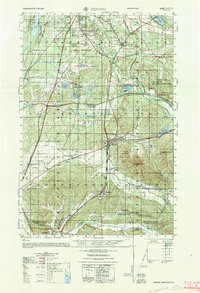
1964 Map of Tenino
USGS Topo · Published 1965About this map
Tumwater and the southern reaches of the Puget Sound region are documented here in the mid-1960s, a period marked by both suburban growth and heavy industrial activity. The landscape transition from the Olympia Municipal Airport down to the coal-rich Hannaford Valley illustrates the region's diverse economic base, from aviation to extraction. A unique historical legacy is visible near Bush Prairie, where an Machine gun bunker (abandoned) and a Sunken rodeo arena sit near the Brighton Park Grange.
Find a feature on this map
78 named features on this map. Tap any name to fly to it.
Don’t see what you’re looking for? This feature index may not catch every label — zoom into the map to look around manually.
Map Details
Editions of this 1964 Tenino Map
This is the sole edition of this map. No revisions or reprints were ever made.
Other maps of this area

1916 · Chehalis
USGS Topo · 1:125,000

1937 · Olympia
USGS Topo · 1:62,500

1939 · Shelton
USGS Topo · 1:62,500

1940 · Tenino
USGS Topo · 1:62,500

1940 · Anderson Island
USGS Topo · 1:62,500

1941 · Meskill
USGS Topo · 1:62,500

1941 · Gate
USGS Topo · 1:62,500

1943 · Willapa
USGS Topo · 1:62,500

1944 · Tenino
USGS Topo · 1:62,500

1944 · Yelm
USGS Topo · 1:62,500