
1944 Map of Yelm
USGS Topo · Published 1944About this map
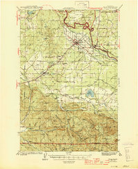
The Nisqually River and Deschutes River anchor this mid-century look at the prairies and timbered ridges of Thurston and Pierce Counties. During this era of active military and industrial expansion, the Centralia Power Plant and the sprawling Fort Lewis Military Reservation dominate the northern landscape, while the Yelm Canal carves through the terrain near Yelm. The rail network is particularly dense here, featuring the Northern Pacific and the Chicago Milwaukee St Paul and Pacific lines connecting agricultural hubs like Rainier and McKenna.
Find a feature on this map
66 named features on this map. Tap any name to fly to it.
Don’t see what you’re looking for? This feature index may not catch every label — zoom into the map to look around manually.
Map Details
Editions of this 1944 Yelm Map
2 editions found
Other maps of this area

1897 · Tacoma
USGS Topo · 1:125,000

1900 · Tacoma
USGS Topo · 1:125,000

1916 · Chehalis
USGS Topo · 1:125,000

1937 · Olympia
USGS Topo · 1:62,500

1937 · Eatonville
USGS Topo · 1:125,000

1940 · Tenino
USGS Topo · 1:62,500

1940 · Anderson Island
USGS Topo · 1:62,500

1941 · Tanwax Lake
USGS Topo · 1:62,500

1941 · Tacoma South
USGS Topo · 1:62,500

1943 · Willapa
USGS Topo · 1:62,500