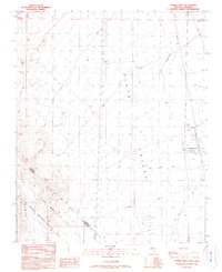
1989 Map of Tenmile Well
USGS Topo · Published 1990About this map
Cal-Nev-Ari occupies the high desert landscape of the Piute Valley in this late-twentieth-century survey. The map documents the community and its Kidwell Airport at a time of established desert settlement along the Nevada-California state line. To the west, the boundary of the East Mojave National Scenic Area marks a transition into protected lands, where the terrain is crossed by the historic Von Schmidt Boundary. This line, surveyed in the 1870s to define the border between California and Nevada, remains a prominent cultural landmark on the desert floor.
Find a feature on this map
21 named features on this map. Tap any name to fly to it.
Don’t see what you’re looking for? This feature index may not catch every label — zoom into the map to look around manually.
Map Details
Editions of this 1989 Tenmile Well Map
This is the sole edition of this map. No revisions or reprints were ever made.
Other maps of this area

1886 · Camp Mohave
USGS Topo · 1:250,000

1892 · Camp Mohave
USGS Topo · 1:250,000

1910 · Ivanpah
USGS Topo · 1:250,000

1912 · Ivanpah
USGS Topo · 1:250,000

1926 · Mohave City
USGS Topo · 1:96,000

1942 · Camp Mohave
USGS Topo · 1:250,000

1942 · Ivanpah
USGS Topo · 1:250,000

1947 · Kingman
USGS Topo · 1:250,000

1948 · Kingman
USGS Topo · 1:250,000

1954 · Kingman
USGS Topo · 1:250,000