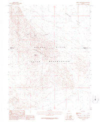
1987 Map of Terrill Mountains
USGS Topo · Published 1987About this map
The Walker River Indian Reservation covers much of this high-desert landscape in Mineral and Churchill Counties, dominated by the prominent peaks of the Terrill Mountains. This 1987 provisional edition documents a region defined by its geological character and a history of extraction, most notably at Camp Terrill. Mining activity is scattered across the slopes, with the Pyramid Mine and Black Butte Mine situated near the northern ridges. To the north, the terrain transitions into the broad expanse of Rawhide Flats, while the southwestern corner is marked by the distinctive formations of the Calico Hills. The map serves as a detailed record of the intersections between federal land management, tribal sovereignty, and mineral exploration in the late twentieth century, including landmarks like Brown Knob that guide navigation through this arid basin and range territory.
Find a feature on this map
9 named features on this map. Tap any name to fly to it.
Don’t see what you’re looking for? This feature index may not catch every label — zoom into the map to look around manually.
Map Details
Editions of this 1987 Terrill Mountains Map
This is the sole edition of this map. No revisions or reprints were ever made.
Other maps of this area

1908 · Carson Sink
USGS Topo · 1:250,000

1909 · Hawthorne
USGS Topo · 1:250,000

1910 · Carson Sink
USGS Topo · 1:250,000

1911 · Hawthorne
USGS Topo · 1:250,000

1915 · Hawthorne
USGS Topo · 1:250,000

1948 · Walker Lake
USGS Topo · 1:250,000

1951 · Allen Springs
USGS Topo · 1:62,500

1951 · Weber Reservoir
USGS Topo · 1:62,500

1957 · Walker Lake
USGS Topo · 1:250,000

1957 · Reno
USGS Topo · 1:250,000