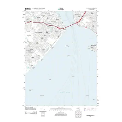
2011 Map of The Narrows
USGS Topo · Published 2011About this map
Fort Wadsworth and Fort Hamilton anchor the defense of the harbor's narrowest point, framing the lower bay and the massive Verrazano-Narrows Bridge. This 2011 topographic record shows the dense suburbanization of Staten Island and Brooklyn, where historic residential areas like Dyker Heights and Castleton Corners meet the coast. The maritime infrastructure of The Narrows is heavily detailed, featuring the numerous shipping berths from Pier 19 to Pier 25 and the critical aids to navigation like West Bank Lighthouse and the Coney Island Lighthouse at Seagate. On land, the map highlights significant cultural and institutional grounds, including the expansive Moravian Cemetery and the Saint John's University Staten Island Campus on Grymes Hill. The transition from urban centers to the recreational shorelines of Coney Island Beach and Midland Beach is clearly visible, connected by the arterial Belt Pkwy and Franklin D Roosevelt Boardwalk.
Find a feature on this map
94 named features on this map. Tap any name to fly to it.
Don’t see what you’re looking for? This feature index may not catch every label — zoom into the map to look around manually.
Map Details
Editions of this 2011 The Narrows Map
This is the sole edition of this map. No revisions or reprints were ever made.
Other maps of this area

1888 · Sandy Hook
USGS Topo · 1:62,500

1889 · Brooklyn
USGS Topo · 1:62,500

1891 · Brooklyn
USGS Topo · 1:62,500

1893 · Sandy Hook
USGS Topo · 1:62,500

1897 · Brooklyn
USGS Topo · 1:62,500

1898 · Staten Island
USGS Topo · 1:62,500

1898 · Brooklyn
USGS Topo · 1:62,500

1900 · Passaic
USGS Topo · 1:125,000

1900 · Staten Island
USGS Topo · 1:62,500

1900 · Brooklyn
USGS Topo · 1:62,500