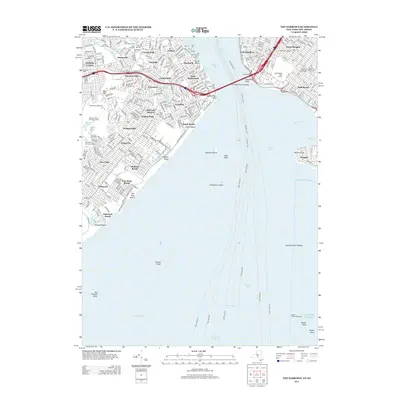
2013 Map of The Narrows
USGS Topo · Published 2013About this map
Fort Wadsworth and Fort Hamilton stand as historic sentinels guarding the entrance to New York Harbor, connected by the massive span of the Verrazano-Narrows Bridge. This survey of the Staten Island shoreline and southwestern Brooklyn reveals a dense landscape of early twentieth-century suburban development and older burial grounds. Large greenspaces like the Moravian Cem and Silver Lake Reservoir contrast with the tight street grids of Concord and Dongan Hills. Along the coast, established maritime features such as the Fort Wadsworth Light and numerous piers near Clifton underscore the area's long-standing naval and commercial importance. Inland, the high ground of Todt Hill and Grymes Hill rises above the low-lying coastal reaches of Midland Beach and New Dorp Beach, offering a detailed view of the terrain that defined the expansion of the outer boroughs.
Find a feature on this map
69 named features on this map. Tap any name to fly to it.
Don’t see what you’re looking for? This feature index may not catch every label — zoom into the map to look around manually.
Map Details
Editions of this 2013 The Narrows Map
This is the sole edition of this map. No revisions or reprints were ever made.
Other maps of this area

1888 · Sandy Hook
USGS Topo · 1:62,500

1889 · Brooklyn
USGS Topo · 1:62,500

1891 · Brooklyn
USGS Topo · 1:62,500

1893 · Sandy Hook
USGS Topo · 1:62,500

1897 · Brooklyn
USGS Topo · 1:62,500

1898 · Staten Island
USGS Topo · 1:62,500

1898 · Brooklyn
USGS Topo · 1:62,500

1900 · Passaic
USGS Topo · 1:125,000

1900 · Staten Island
USGS Topo · 1:62,500

1900 · Brooklyn
USGS Topo · 1:62,500