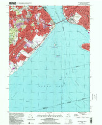
1998 Map of The Narrows
USGS Topo · Published 2001About this map
Todt Hill and Grymes Hill dominate the interior landscape of Staten Island, overlooking a densely settled corridor of neighborhoods that stretch from Stapleton down to Oakwood. This late 20th-century survey illustrates the vital transportation and military infrastructure defining the region, anchored by the Verrazano-Narrows Bridge connecting Richmond to New Utrecht and Bath Beach. The coastal defense legacy is prominent at Fort Wadsworth and the U.S. Military Res Fort Hamilton, which flank the entrance to the harbor. Along the eastern shore, the Franklin D Roosevelt Boardwalk links South Beach and Midland Beach, while the Staten Island Rapid Transit line cuts through the historic village centers of Dongan Hills and Grant City. The map also details extensive open spaces, from the large Moravian Cemetery to the waterfront reaches of Gateway Nat Recreation Area.
Find a feature on this map
92 named features on this map. Tap any name to fly to it.
Don’t see what you’re looking for? This feature index may not catch every label — zoom into the map to look around manually.
Map Details
Editions of this 1998 The Narrows Map
This is the sole edition of this map. No revisions or reprints were ever made.
Other maps of this area

1888 · Sandy Hook
USGS Topo · 1:62,500

1889 · Brooklyn
USGS Topo · 1:62,500

1891 · Brooklyn
USGS Topo · 1:62,500

1893 · Sandy Hook
USGS Topo · 1:62,500

1897 · Brooklyn
USGS Topo · 1:62,500

1898 · Staten Island
USGS Topo · 1:62,500

1898 · Brooklyn
USGS Topo · 1:62,500

1900 · Passaic
USGS Topo · 1:125,000

1900 · Staten Island
USGS Topo · 1:62,500

1900 · Brooklyn
USGS Topo · 1:62,500