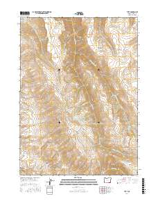
2017 Map of The V
USGS Topo · Published 2017About this map
The Trout Creek Mountains dominate this high-desert landscape in southeastern Oregon, where a network of ephemeral and perennial streams carves through the high plateau. The map's title refers to The V, a prominent topographic formation that sits amidst several drainages including Big Trout Cr and Rock Cabin Cr. This area is defined by its critical water sources, evidenced by the numerous named springs such as Amos Spring, Government Spring, and No Name Spring that support life in the arid terrain.
Find a feature on this map
34 named features on this map. Tap any name to fly to it.
Don’t see what you’re looking for? This feature index may not catch every label — zoom into the map to look around manually.
Map Details
Editions of this 2017 The V Map
This is the sole edition of this map. No revisions or reprints were ever made.
Other maps of this area

1886 · Disaster
USGS Topo · 1:250,000

1893 · Disaster
USGS Topo · 1:250,000

1954 · Vya
USGS Topo · 1:250,000

1955 · Adel
USGS Topo · 1:250,000

1957 · Adel
USGS Topo · 1:250,000

1958 · Vya
USGS Topo · 1:250,000

1958 · Adel
USGS Topo · 1:250,000
1961 · Trident Peak
USGS Topo · 1:62,500
1961 · Disaster Peak
USGS Topo · 1:62,500

1962 · Vya
USGS Topo · 1:250,000