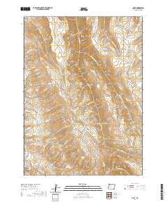
2020 Map of The V
USGS Topo · Published 2020About this map
The Trout Creek Mountains dominate this high-desert landscape in southeastern Harney County, where steep drainages and isolated springs define the remote terrain. This 2020 survey reveals a complex hydrological network centered around the headwaters of the Kings River and the significant drainage of Big Trout Creek. The map is characterized by its prominent ridges and peaks, most notably Catlow Peak and the distinctive topographic formation known as The V. Named features like Marking Corral Canyon and Mahogany Ridge suggest a history of seasonal grazing and land use in this arid corner of Oregon. Critical water sources for local wildlife and livestock are meticulously documented, including Amos Spring, Government Spring, and Burro Spring. This sheet offers a precise look at the land's natural contours before they give way to the East Basin.
Find a feature on this map
34 named features on this map. Tap any name to fly to it.
Don’t see what you’re looking for? This feature index may not catch every label — zoom into the map to look around manually.
Map Details
Editions of this 2020 The V Map
This is the sole edition of this map. No revisions or reprints were ever made.
Other maps of this area

1886 · Disaster
USGS Topo · 1:250,000

1893 · Disaster
USGS Topo · 1:250,000

1954 · Vya
USGS Topo · 1:250,000

1955 · Adel
USGS Topo · 1:250,000

1957 · Adel
USGS Topo · 1:250,000

1958 · Vya
USGS Topo · 1:250,000

1958 · Adel
USGS Topo · 1:250,000

1961 · Trident Peak
USGS Topo · 1:62,500

1961 · Disaster Peak
USGS Topo · 1:62,500

1962 · Vya
USGS Topo · 1:250,000