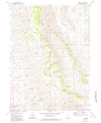
1982 Map of The V
USGS Topo · Published 1982About this map
Gatlow Peak stands as a prominent high point within the Trout Creek Mountains of Harney County, defining a landscape shaped by high-desert drainage systems and livestock history. The 1982 map reveals a network of water sources essential for cattle ranching, including the Burro Spring Water Tank, Sagehen Spring, and numerous unnamed springs that feed into Big Trout Creek and the East Fork Trout Creek. Evidence of land use is found in the scattered structures like the Rock Cabin and historical enclosures such as the Government Corral, Marking Corral, and Horseshoe Corral. The namesake geographic feature The V dominates the southeastern quadrant, while the northern reaches are defined by the broad elevations of Mahogany Ridge and Smith Field. The terrain is deeply incised by drainages such as Marking Corral Canyon and Middle Canyon, which flow toward the East Basin.
Find a feature on this map
33 named features on this map. Tap any name to fly to it.
Don’t see what you’re looking for? This feature index may not catch every label — zoom into the map to look around manually.
Map Details
Editions of this 1982 The V Map
This is the sole edition of this map. No revisions or reprints were ever made.
Other maps of this area

1886 · Disaster
USGS Topo · 1:250,000

1893 · Disaster
USGS Topo · 1:250,000

1954 · Vya
USGS Topo · 1:250,000

1955 · Adel
USGS Topo · 1:250,000

1957 · Adel
USGS Topo · 1:250,000

1958 · Vya
USGS Topo · 1:250,000

1958 · Adel
USGS Topo · 1:250,000

1961 · Trident Peak
USGS Topo · 1:62,500

1961 · Disaster Peak
USGS Topo · 1:62,500

1962 · Vya
USGS Topo · 1:250,000