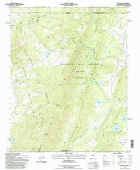
1995 Map of The Wall
USGS Topo · Published 1997About this map
The Beaubien and Miranda Grant (Maxwell) and the Sangre de Cristo Grant converge in this high-altitude corner of the Sangre de Cristo Mountains, where the Colorado and New Mexico border meets the intersection of Costilla, Colfax, and Taos counties. The landscape is defined by the massive geological formations known as The Wall and Little The Wall, which create a natural barrier running north to south. Human presence is sparse and focused on resource extraction and remote outposts, including the Van Diest Mine and several isolated dwellings such as the Bernal Cabin, Number One Camp, and Cressmer Lodge.
Find a feature on this map
44 named features on this map. Tap any name to fly to it.
Don’t see what you’re looking for? This feature index may not catch every label — zoom into the map to look around manually.
Map Details
Editions of this 1995 The Wall Map
This is the sole edition of this map. No revisions or reprints were ever made.
Other maps of this area

1954 · Raton
USGS Topo · 1:250,000

1954 · Trinidad
USGS Topo · 1:250,000

1955 · Trinidad
USGS Topo · 1:250,000

1958 · Raton
USGS Topo · 1:250,000

1958 · Trinidad
USGS Topo · 1:250,000

1959 · Trinidad
USGS Topo · 1:250,000

1962 · Ash Mountain
USGS Topo · 1:62,500

1963 · Comanche Point
USGS Topo · 1:24,000

1963 · Big Costilla Peak
USGS Topo · 1:24,000

1967 · La Valley
USGS Topo · 1:24,000