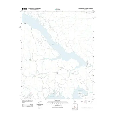
2012 Map of Tierra Redonda Mountain
USGS Topo · Published 2012About this map
Lake San Antonio and Lake Nacimiento dominate this central California landscape, reflecting the modern management of the San Antonio River and Nacimiento River systems. The map captures a mix of recreation and ranching life, centered on the prominent Tierra Redonda Mountain. Smaller inland settlements such as Pleyto, Lynch Ranch, and Bee Rock are connected by a network of rural routes including Interlake Rd and Bee Rock Rd. Near the southern shoreline, the Nacimiento Lake Marina and residential developments like those along Heritage Rd indicate the area's transition into a seasonal destination. To the north, the terrain transitions through Harris Valley toward the Hames Valley Hall area, showing how the local infrastructure supports both the high-elevation peaks and the developed reservoir basins.
Find a feature on this map
26 named features on this map. Tap any name to fly to it.
Don’t see what you’re looking for? This feature index may not catch every label — zoom into the map to look around manually.
Map Details
Editions of this 2012 Tierra Redonda Mountain Map
This is the sole edition of this map. No revisions or reprints were ever made.
Other maps of this area

1919 · Bryson
USGS Topo · 1:62,500

1919 · Bradley
USGS Topo · 1:62,500

1919 · Adelaida
USGS Topo · 1:62,500

1919 · San Simeon
USGS Topo · 1:62,500

1932 · Adelaida
USGS Topo · 1:62,500

1937 · San Simeon
USGS Topo · 1:62,500

1941 · Bradley
USGS Topo · 1:62,500

1941 · Bryson
USGS Topo · 1:62,500

1942 · Adelaida
USGS Topo · 1:62,500

1942 · Bryson
USGS Topo · 1:62,500