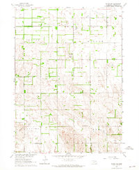
1963 Map of Tilden NW
USGS Topo · Published 1964About this map
The agrarian landscape of Antelope County is defined here by the intersection of four townships: Custer, Willow, Neligh, and Elm. This early 1960s survey documents a dense network of local education, including Willowdale Sch and Black Lake Sch, alongside numbered landmarks such as School No 27 and School No 72. These small schoolhouses, spaced periodically across the grid, reflect the rural community structure of the Missouri River Basin development era.
Find a feature on this map
14 named features on this map. Tap any name to fly to it.
Don’t see what you’re looking for? This feature index may not catch every label — zoom into the map to look around manually.
Map Details
Editions of this 1963 Tilden NW Map
This is the sole edition of this map. No revisions or reprints were ever made.
Other maps of this area

1955 · Sioux City
USGS Topo · 1:250,000

1955 · O'Neill
USGS Topo · 1:250,000

1958 · Sioux City
USGS Topo · 1:250,000

1959 · O'Neill
USGS Topo · 1:250,000

1959 · Sioux City
USGS Topo · 1:250,000

1963 · Neligh
USGS Topo · 1:24,000

1963 · Neligh SE
USGS Topo · 1:24,000
1963 · Oakdale
USGS Topo · 1:24,000

1963 · Plainview
USGS Topo · 1:24,000

1963 · Brunswick
USGS Topo · 1:24,000