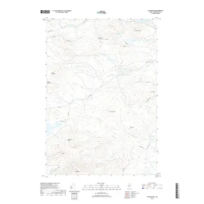
2018 Map of Tim Mountain
USGS Topo · Published 2018About this map
Tim Mtn and the surrounding peaks of the Barnard Mountains dominate this portion of the Maine interior, where the landscape is defined by its complex drainage systems and high-elevation basins. Large water bodies such as Tim Pond and Tea Pond are central features, fed by a network of named brooks including Barnard Brook and Sawyer Brook. The terrain transitions from the low-lying Big Sag Basin in the southwest to the elevated reaches of Eustis Ridge in the east. The map records a dense web of backcountry access ways, such as Tea Pond Rd and Alder Stream Rd, which trace the valleys between ridges like Mud Pond Ridge and the Lookout Hills. This network reflects the area's history of timber management and seasonal recreation, providing clear documentation of the forest tracks and water routes near East Kennebago Mtn as they existed in the late 2010s.
Find a feature on this map
43 named features on this map. Tap any name to fly to it.
Don’t see what you’re looking for? This feature index may not catch every label — zoom into the map to look around manually.
Map Details
Editions of this 2018 Tim Mountain Map
This is the sole edition of this map. No revisions or reprints were ever made.
Other maps of this area

1928 · Chain Lakes
USGS Topo · 1:48,000

1928 · Spencer
USGS Topo · 1:48,000

1928 · Stratton
USGS Topo · 1:48,000

1932 · Stratton
USGS Topo · 1:62,500

1932 · Kennebago Lake
USGS Topo · 1:48,000

1932 · Spencer
USGS Topo · 1:62,500

1932 · Chain Lakes
USGS Topo · 1:62,500

1935 · Kennebago Lake
USGS Topo · 1:62,500

1935 · Chain Lakes
USGS Topo · 1:62,500

1936 · Kennebago Lake
USGS Topo · 1:62,500