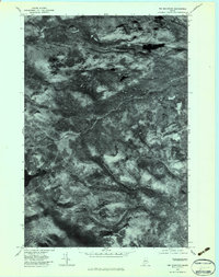
1977 Map of Tim Mountain
USGS Topo · Published 1983About this map
Tim Mountain and the surrounding wilderness of Franklin County appear here in high-contrast detail, captured during a late October 1977 aerial survey. This orthophotoquad provides a clear view of the dense forest cover and hydrologic patterns of the Maine woods before the onset of winter. The landscape is defined by significant water bodies such as Tim Pond and the winding course of the North Branch Dead R in the north. The drainage network is visible through the paths of Tim Brook, Alder Stream, and Lutton Brook, which carve through the high elevations of East Kennebago Mountain. This imagery is particularly valuable for identifying logging roads and natural clearings in a region where few permanent settlements exist, showing the timberland's character just as it was in the late 1970s.
Find a feature on this map
7 named features on this map. Tap any name to fly to it.
Don’t see what you’re looking for? This feature index may not catch every label — zoom into the map to look around manually.
Map Details
Editions of this 1977 Tim Mountain Map
This is the sole edition of this map. No revisions or reprints were ever made.
Other maps of this area

1928 · Chain Lakes
USGS Topo · 1:48,000

1928 · Spencer
USGS Topo · 1:48,000

1928 · Stratton
USGS Topo · 1:48,000

1932 · Stratton
USGS Topo · 1:62,500

1932 · Kennebago Lake
USGS Topo · 1:48,000

1932 · Spencer
USGS Topo · 1:62,500

1932 · Chain Lakes
USGS Topo · 1:62,500

1935 · Kennebago Lake
USGS Topo · 1:62,500

1935 · Chain Lakes
USGS Topo · 1:62,500

1936 · Kennebago Lake
USGS Topo · 1:62,500