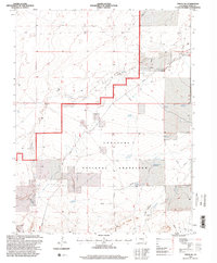
1996 Map of Timpas SW
USGS Topo · Published 2000About this map
The Comanche National Grassland dominates this section of Otero County, revealing a landscape defined by the essential search for water in the high plains. Unlike more densely settled agricultural regions, the topography here is shaped by intermittent drainages like West Dry Creek and South Dry Creek, where ranching operations have established a network of reservoirs and windmills. Significant water features such as Larson Reservoir, Anderson Reservoir, and Haight Reservoir indicate the effort to capture seasonal runoff for livestock. The map provides a look at isolated outposts like Dry Creek Camp and family-named infrastructure including the Swisher Windmill and Reed Windmill, which served as critical landmarks for 20th-century land management within the national grassland.
Find a feature on this map
21 named features on this map. Tap any name to fly to it.
Don’t see what you’re looking for? This feature index may not catch every label — zoom into the map to look around manually.
Map Details
Editions of this 1996 Timpas SW Map
This is the sole edition of this map. No revisions or reprints were ever made.
Other maps of this area

1891 · Timpas
USGS Topo · 1:125,000

1891 · Apishapa
USGS Topo · 1:125,000

1893 · Apishapa
USGS Topo · 1:125,000

1894 · Timpas
USGS Topo · 1:125,000

1897 · Apishapa
USGS Topo · 1:125,000

1954 · Trinidad
USGS Topo · 1:250,000

1955 · La Junta
USGS Topo · 1:250,000

1955 · Trinidad
USGS Topo · 1:250,000

1958 · La Junta
USGS Topo · 1:250,000

1958 · Trinidad
USGS Topo · 1:250,000