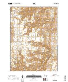
2020 Map of Tims Peak
USGS Topo · Published 2020About this map
Tims Peak and the high desert terrain of Malheur County define this 2020 landscape, characterized by a complex network of seasonal drainages and managed water resources. The presence of numerous small-scale catchments, such as Gold Cr Reservoir Number One and the Shearing Plant Reservoir, highlights the critical nature of water management for livestock and industry in this arid region. The terrain is marked by distinctive elevations like Hat Top and depressions including Simmons Gulch, showing the natural runoff patterns that feed into Wildcat Cr and Cottonwood Cr. Human activity is further evidenced by the Sunnyslope Pit, reflecting the area's geological utility. Local history is traced through family-named or descriptive landmarks like Gacey Spring and Antelope Swale, which point to the long-standing use of these rangelands for grazing and local navigation across the eastern Oregon high country.
Find a feature on this map
44 named features on this map. Tap any name to fly to it.
Don’t see what you’re looking for? This feature index may not catch every label — zoom into the map to look around manually.
Map Details
Editions of this 2020 Tims Peak Map
This is the sole edition of this map. No revisions or reprints were ever made.
Other maps of this area
1955 · Boise
USGS Topo · 1:250,000
1958 · Boise
USGS Topo · 1:250,000
1962 · Boise
USGS Topo · 1:250,000
1966 · Harper
USGS Topo · 1:62,500
1966 · Westfall Butte
USGS Topo · 1:62,500
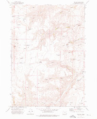
1972 · Tims Peak
USGS Topo · 1:24,000
1972 · Shumway Reservoir
USGS Topo · 1:24,000
1972 · Alder Creek
USGS Topo · 1:24,000
1972 · Avery Creek
USGS Topo · 1:24,000
1972 · Rufino Butte
USGS Topo · 1:24,000