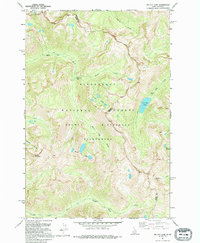
1991 Map of Tin Cup Lake
USGS Topo · Published 1995About this map
Vance Mountain anchors the high divide of the Bitterroot National Forest on this topographic study of the Idaho-Montana border. The landscape is defined by its drainage basins and high-elevation water bodies, notably Tin Cup Lake and the clustered Triple Lakes. These alpine waters feed a complex network of streams including Tin Cup Creek and White Cap Creek, which flow through the protected expanse of the Selway Bitterroot Wilderness. A primary Pack Trail serves as the essential corridor for movement through the backcountry, tracing the ridges and valleys between Idaho Co. and Ravalli Co. The map documents the region's wilderness character in the early 1990s, recording features like Patsy Ann Falls and White Cap Lakes before modern environmental shifts altered these high-country waterways.
Find a feature on this map
18 named features on this map. Tap any name to fly to it.
Don’t see what you’re looking for? This feature index may not catch every label — zoom into the map to look around manually.
Map Details
Editions of this 1991 Tin Cup Lake Map
This is the sole edition of this map. No revisions or reprints were ever made.
Other maps of this area

1901 · Hamilton
USGS Topo · 1:125,000

1911 · Lolo
USGS Topo · 1:250,000

1913 · Lolo
USGS Topo · 1:250,000

1956 · Elk City
USGS Topo · 1:250,000

1956 · Hamilton
USGS Topo · 1:250,000

1959 · Hamilton
USGS Topo · 1:250,000

1960 · Elk City
USGS Topo · 1:250,000

1960 · Hamilton
USGS Topo · 1:250,000

1964 · Hamilton
USGS Topo · 1:250,000

1964 · Boulder Peak
USGS Topo · 1:24,000