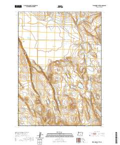
2020 Map of Tired Horse Butte
USGS Topo · Published 2020About this map
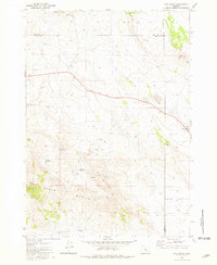
Tired Horse Butte and Pilot Butte command this high desert landscape in Lake County, defining a region where water management is the primary marker of human activity. The map reveals an intricate network of localized hydrology designed to support livestock and survival in an arid environment, including Stauffer Reservoir, Wagontire Mountain Reservoir, and the East Immigrant Waterhole. These features, alongside the Sinks of Lost Creek, trace the natural drainage patterns across Overall Flat and through the descent of Stauffer Rim. While the terrain appears sparse, the naming of specific water sources like Juniper Lake Reservoir and Tired Horse Reservoir suggests a history of range use and seasonal migration through this section of the Oregon outback.
Find a feature on this map
16 named features on this map. Tap any name to fly to it.
Don’t see what you’re looking for? This feature index may not catch every label — zoom into the map to look around manually.
Map Details
Editions of this 2020 Tired Horse Butte Map
This is the sole edition of this map. No revisions or reprints were ever made.
Other maps of this area

1955 · Crescent
USGS Topo · 1:250,000

1955 · Burns
USGS Topo · 1:250,000

1957 · Crescent
USGS Topo · 1:250,000

1958 · Crescent
USGS Topo · 1:250,000

1958 · Burns
USGS Topo · 1:250,000

1959 · Burns
USGS Topo · 1:250,000
1970 · Crescent
USGS Topo · 1:250,000
1980 · Wagontire Mtn West
USGS Topo · 1:24,000
1980 · Round Top Butte
USGS Topo · 1:24,000
1981 · Hat Butte
USGS Topo · 1:24,000