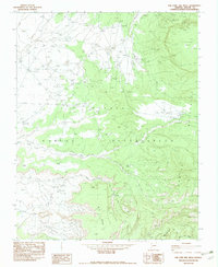
1982 Map of Toh Chin Lini Mesa
USGS Topo · Published 1982About this map
Navajo Indian Reservation lands in Apache County are documented here in high detail, showcasing a landscape defined by dramatic plateaus and deeply cut drainage systems. The topography is dominated by massive elevated features like Chezhindeza Mesa and the central Toh Chin Lini Mesa, which are separated by the complex erosion of the Toh Chin Lini Canyon. These landforms dictate the placement of local resource activity, such as the Martin Mine and Sah Tah Mine located in the northern reaches of the quadrangle.
Find a feature on this map
15 named features on this map. Tap any name to fly to it.
Don’t see what you’re looking for? This feature index may not catch every label — zoom into the map to look around manually.
Map Details
Editions of this 1982 Toh Chin Lini Mesa Map
This is the sole edition of this map. No revisions or reprints were ever made.
Other maps of this area

1892 · Canyon De Chelly
USGS Topo · 1:250,000

1953 · Los Gigantes NE
USGS Topo · 1:24,000

1953 · Los Gigantes NW
USGS Topo · 1:24,000

1953 · Dinne Mesa NW
USGS Topo · 1:24,000

1953 · Pastora Peak SW
USGS Topo · 1:24,000

1953 · Pastora Peak NW
USGS Topo · 1:24,000

1953 · Dinne Mesa NE
USGS Topo · 1:24,000

1953 · Dinne Mesa SW
USGS Topo · 1:24,000

1953 · Redrock Valley NW
USGS Topo · 1:24,000

1953 · Dinne Mesa SE
USGS Topo · 1:24,000