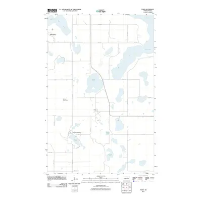
2011 Map of Tokio
USGS Topo · Published 2011About this map
Tokio and Saint Michael anchor this 2011 survey of the Wood Lake District, where a complex network of glacial lakes and prairie wetlands dominates the North Dakota landscape. The map centers on the community of Tokio, situated at a crossroads of local routes like Bia 21, while Saint Michael sits further northwest near the shores of Mission Bay. The hydrology of the region is notably intricate, featuring large bodies like Devils Lake and its northern extension, Black Tiger Bay, alongside smaller prairie potholes such as Spring Lake, Square Lake, and Mallard Lake. A prominent geological landmark, Devils Heart Butte, rises above the surrounding plains to the west of Tokio. To the south, the Wood Lake Marsh Dam regulates water levels between Wood Lake and the adjacent marshlands, illustrating local water management practices within this glaciated terrain.
Find a feature on this map
29 named features on this map. Tap any name to fly to it.
Don’t see what you’re looking for? This feature index may not catch every label — zoom into the map to look around manually.
Map Details
Editions of this 2011 Tokio Map
This is the sole edition of this map. No revisions or reprints were ever made.
Other maps of this area

1928 · Tokio
USGS Topo · 1:62,500

1930 · Hamar
USGS Topo · 1:62,500

1931 · Tokio
USGS Topo · 1:62,500

1931 · Devils Lake
USGS Topo · 1:62,500
1950 · Tokio SW
USGS Topo · 1:24,000

1950 · Tokio
USGS Topo · 1:24,000

1950 · Devils Lake
USGS Topo · 1:62,500

1951 · Crary
USGS Topo · 1:24,000

1951 · Devils Lake
USGS Topo · 1:24,000

1951 · Camp Grafton
USGS Topo · 1:24,000
Featured Places
- Wood Lake District, ND
- St. Michael District, ND
- Tokio, ND
- St. Michael, St. Michael District
- Benson County, ND