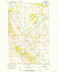
1950 Map of Tokio
USGS Topo · Published 1952About this map
The Great Northern RR cuts a diagonal path across this 1950 landscape, connecting the village of Tokio to the wider region. This area of Benson County is defined by the variable shoreline of the Devils Lake basin, which at this mid-century moment shows distinct reaches like Black Tiger Bay, South Bay, and Mission Bay. The topography is a complex arrangement of glacial depressions and ridges, most notably Devils Heart Butte, which rises sharply above the surrounding prairie.
Find a feature on this map
25 named features on this map. Tap any name to fly to it.
Don’t see what you’re looking for? This feature index may not catch every label — zoom into the map to look around manually.
Map Details
Editions of this 1950 Tokio Map
This is the sole edition of this map. No revisions or reprints were ever made.
Other maps of this area
1928 · Tokio
USGS Topo · 1:62,500
1930 · Hamar
USGS Topo · 1:62,500
1931 · Tokio
USGS Topo · 1:62,500
1931 · Devils Lake
USGS Topo · 1:62,500
1950 · Tokio SW
USGS Topo · 1:24,000
1950 · Devils Lake
USGS Topo · 1:62,500
1951 · Crary
USGS Topo · 1:24,000
1951 · Devils Lake
USGS Topo · 1:24,000
1951 · Camp Grafton
USGS Topo · 1:24,000
1951 · Free Peoples Lake
USGS Topo · 1:24,000
Featured Places
- Wood Lake District, ND
- St. Michael District, ND
- St. Michael, St. Michael District
- Tokio, ND
- Ramsey County, ND