1996 Map of Tol South
USGS Topo · Published 2004About this map
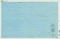
Chuuk Lagoon and the surrounding Pacific Ocean define this 1996 survey, which documents a string of islets and reef formations along the southern perimeter of the Tol area. Based on topographic data from 1968 and imagery from the mid-1990s, the map provides a look at the remote geography of the Federated States of Micronesia during a period of transition under the Trust Territory of the Pacific Islands. Named landforms such as Onnang, Onno, and the small outcrop of Fanasich emerge from the Coral Reef, illustrating the delicate physical nature of these Pacific atolls. To the east, the map identifies the passage of Mochun Nepis and the grouping of islets including Fanew, Pinepin, and Maimai. This record serves as a precise navigational and topographic reference for the scattered points of land that form the maritime landscape of the State of Chuuk.
Find a feature on this map
23 named features on this map. Tap any name to fly to it.
Don’t see what you’re looking for? This feature index may not catch every label — zoom into the map to look around manually.
Map Details
Editions of this 1996 Tol South Map
This is the sole edition of this map. No revisions or reprints were ever made.