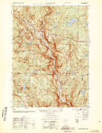
1954 Map of Tolland
USGS Topo · Published 1954About this map
The Farmington River West Branch carves a deep valley through this mid-century landscape on the Massachusetts-Connecticut border. This 1954 edition, compiled by the Army Map Service, documents the rural character of the southern Berkshires and northern Litchfield County just as post-war recreation began to define the region. Large tracts of protected land, including the Sandisfield State Forest and Tolland State Forest, surround small crossroads settlements like New Boston and West New Boston. The map traces a network of high-elevation water bodies from Mirror Lake to Pinehurst Lake, alongside family-named landmarks like Noyes Hill and Babbitt Mtn. In the southern portion, the hamlet of North Colebrook and the site of Camp Wynbrooke reflect the area’s transition from early industrial milling sites toward a seasonal retreat character, all while maintaining the rugged, forested topography that separates the village of Tolland Center from its neighbors.
Find a feature on this map
60 named features on this map. Tap any name to fly to it.
Don’t see what you’re looking for? This feature index may not catch every label — zoom into the map to look around manually.
Map Details
Editions of this 1954 Tolland Map
This is the sole edition of this map. No revisions or reprints were ever made.
Other maps of this area

1887 · Granville
USGS Topo · 1:62,500

1888 · Sandisfield
USGS Topo · 1:62,500

1889 · Granville
USGS Topo · 1:62,500

1892 · Winsted
USGS Topo · 1:62,500

1892 · Granby
USGS Topo · 1:62,500

1893 · Granville
USGS Topo · 1:62,500

1893 · Sandisfield
USGS Topo · 1:62,500

1895 · Granville
USGS Topo · 1:62,500

1896 · Holyoke
USGS Topo · 1:125,000

1897 · Sandisfield
USGS Topo · 1:62,500