1949 Map of Tomah
USGS Topo · Published 1949About this map
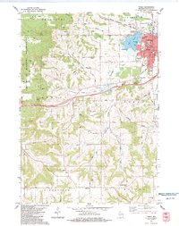
Camp Mc Coy Military Reservation dominates the northwest corner of this post-war landscape, showing the extent of Old Camp McCoy and its various passes like Lafayette Pass and Raymore Pass. The rail infrastructure is particularly dense, with the Chicago Milwaukee St Paul and Pacific and Chicago and North Western lines converging near Tomah and passing through the rugged topography toward Norwalk and Wilton. This 1940s survey reveals a landscape still defined by its rural school districts and family landmarks.
Find a feature on this map
106 named features on this map. Tap any name to fly to it.
Don’t see what you’re looking for? This feature index may not catch every label — zoom into the map to look around manually.
Map Details
Editions of this 1949 Tomah Map
This is the sole edition of this map. No revisions or reprints were ever made.
Historical Maps of Tomah Through Time
4 maps found