
1979 Map of Tooele
USGS Topo · Published 1980About this map
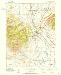
The Tooele Army Depot and the sprawling Open Pit Mine near Bingham dominate the industrial landscape of this late-1970s survey. This portion of northern Utah reveals a complex interface between heavy industry and critical natural preserves, with the Timpie Springs Waterfowl Management Area and Farmington Bay bordering the recessive waters of the Great Salt Lake. Economic infrastructure is well-defined by the extensive Salt Evaporator ponds and the intersecting lines of the Union Pacific and Western Pacific railroads.
Find a feature on this map
67 named features on this map. Tap any name to fly to it.
Don’t see what you’re looking for? This feature index may not catch every label — zoom into the map to look around manually.
Map Details
Editions of this 1979 Tooele Map
This is the sole edition of this map. No revisions or reprints were ever made.
Other maps of this area

1885 · Salt Lake
USGS Topo · 1:250,000

1885 · Tooele Valley
USGS Topo · 1:250,000

1915 · Fairfield
USGS Topo · 1:62,500

1917 · Fairfield
USGS Topo · 1:62,500

1918 · Stockton
USGS Topo · 1:62,500

1925 · Ft. Douglas
USGS Topo · 1:125,000

1928 · Ft. Douglas
USGS Topo · 1:125,000
1951 · Jordan Narrows
USGS Topo · 1:24,000
1951 · Saltair
USGS Topo · 1:24,000

1951 · Salt Lake City South
USGS Topo · 1:24,000