1966 Map of Towaoc
USGS Topo · Published 1969About this map
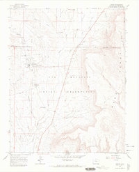
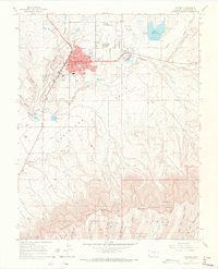
The tribal headquarters of the Ute Mountain Indian Reservation at Towaoc serves as the focal point of this mid-1960s survey. Located within the Montezuma Valley, the community is documented with detailed local landmarks, including the Francis Xavier Ch, an Athletic Field, and the Ute Mtn Indian Racetrack and Rodeo Grounds. The map illustrates a landscape where modern administrative infrastructure meets deep antiquity, evidenced by numerous Indian Ruins scattered across the drainage of Navajo Wash and the preservation of Yucca House National Mon in the north. To the east, the rising terrain of Mesa Verde is marked by Cliff Dwellings tucked into the canyons. Water management in this arid region is critical, visible through the Highline Ditch and the historic Navajo Spring, which likely influenced the placement of early settlements and travel routes throughout the Old Southern Ute Indian Reservation Boundary.
Find a feature on this map
31 named features on this map. Tap any name to fly to it.
Don’t see what you’re looking for? This feature index may not catch every label — zoom into the map to look around manually.
Map Details
Editions of this 1966 Towaoc Map
This is the sole edition of this map. No revisions or reprints were ever made.
Other maps of this area

1956 · Cortez
USGS Topo · 1:250,000

1957 · Moqui SE
USGS Topo · 1:24,000

1958 · Cortez SW
USGS Topo · 1:24,000

1958 · Sentinel Peak NE
USGS Topo · 1:24,000

1958 · Cortez
USGS Topo · 1:250,000

1959 · Cortez
USGS Topo · 1:250,000

1962 · Cortez
USGS Topo · 1:250,000
1965 · Cortez
USGS Topo · 1:24,000

1966 · Cortez
USGS Topo · 1:250,000

1966 · Moqui Canyon
USGS Topo · 1:24,000