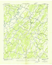
1936 Map of Tranquillity
USGS Topo · Published 1936About this map
Pone Valley and the surrounding ridges of McMinn County define this 1936 rural landscape, surveyed just as the Tennessee Valley Authority began its transformative work in the region. The map reveals a dense network of local institutions essential to Depression-era country life, from the Hickory Flats Sch in the north to the Rogers Creek Ch in the south. Early industrial footprints are visible at Collins Mill and Sewee Mill, while small agricultural hubs like Boggs Crossroads and the eponymous Tranquillity serve as the primary social anchors.
Find a feature on this map
55 named features on this map. Tap any name to fly to it.
Don’t see what you’re looking for? This feature index may not catch every label — zoom into the map to look around manually.
Map Details
Editions of this 1936 Tranquillity Map
This is the sole edition of this map. No revisions or reprints were ever made.
Other maps of this area

1886 · Cleveland
USGS Topo · 1:125,000

1887 · Kingston
USGS Topo · 1:125,000

1891 · Kingston
USGS Topo · 1:125,000

1892 · Cleveland
USGS Topo · 1:125,000

1893 · Kingston
USGS Topo · 1:125,000

1895 · Cleveland
USGS Topo · 1:125,000

1901 · Cleveland
USGS Topo · 1:125,000

1935 · Niota
USGS Topo · 1:24,000

1935 · Athens
USGS Topo · 1:24,000

1935 · Goodfield
USGS Topo · 1:24,000