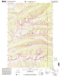
1998 Map of Trapper Peak
USGS Topo · Published 2000About this map
Trapper Peak rises as the central landmark of this high-altitude landscape in the late 1990s, set within the protected expanse of the Bitterroot National Forest and the Selway - Bitterroot Wilderness. The terrain is defined by a series of glacial cirques and alpine lakes, including Kerlee Lake, Chaffin Lake, and Tamarack Lake, which feed the drainage systems of Tin Cup Creek and Chaffin Creek. This map reveals a landscape managed primarily for recreation and conservation, though isolated Mines on the eastern slopes hint at earlier resource extraction efforts.
Find a feature on this map
30 named features on this map. Tap any name to fly to it.
Don’t see what you’re looking for? This feature index may not catch every label — zoom into the map to look around manually.
Map Details
Editions of this 1998 Trapper Peak Map
This is the sole edition of this map. No revisions or reprints were ever made.
Other maps of this area

1901 · Hamilton
USGS Topo · 1:125,000

1956 · Elk City
USGS Topo · 1:250,000

1956 · Hamilton
USGS Topo · 1:250,000

1959 · Hamilton
USGS Topo · 1:250,000

1960 · Elk City
USGS Topo · 1:250,000

1960 · Hamilton
USGS Topo · 1:250,000

1964 · Hamilton
USGS Topo · 1:250,000

1964 · Burnt Ridge
USGS Topo · 1:24,000

1964 · Boulder Peak
USGS Topo · 1:24,000

1964 · Darby
USGS Topo · 1:24,000