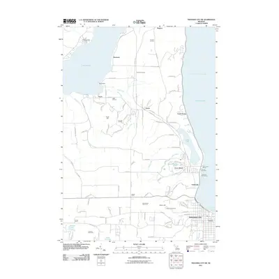
2011 Map of Traverse City SW
USGS Topo · Published 2011About this map
West Arm Grand Traverse Bay and Lake Michigan dominate the eastern edge of this Michigan landscape, where the maritime and recreational character of the region is clearly visible. The survey documents the transition from the bustling waterfront at Greilickville, featuring the Greilickville City Coal Dock and Traverse City Harbor, to the interior agricultural and residential hills. Local genealogy is well-preserved through family-named landmarks like Heimforth and Fouch, along with their respective burial grounds, Heimforth Cemetery and Fouch Cemetery. Educational history is anchored by the Lautner School and Stricker School. The map also illustrates the area's development as a leisure destination, noting the Timberlee Ski Area, Hickory Hills Ski Area, and several golf courses situated between the freshwater shores of Lake Leelanau and the larger bay.
Find a feature on this map
105 named features on this map. Tap any name to fly to it.
Don’t see what you’re looking for? This feature index may not catch every label — zoom into the map to look around manually.
Map Details
Editions of this 2011 Traverse City SW Map
This is the sole edition of this map. No revisions or reprints were ever made.
Other maps of this area

1954 · Traverse City
USGS Topo · 1:250,000

1956 · Kingsley
USGS Topo · 1:62,500

1956 · Thompsonville
USGS Topo · 1:62,500

1957 · Traverse City
USGS Topo · 1:62,500

1957 · Maple City
USGS Topo · 1:62,500

1958 · Traverse City
USGS Topo · 1:250,000

1976 · Thompsonville NE
USGS Topo · 1:24,000

1983 · Maple City
USGS Topo · 1:24,000

1983 · Traverse City SE
USGS Topo · 1:25,000

1983 · Traverse City
USGS Topo · 1:100,000
Featured Places
- Garfield Township, MI
- Traverse City, MI
- Long Lake Township, MI
- Elmwood Charter Township, MI
- Greilickville, Elmwood Charter Township