1986 Map of Trenton
USGS Topo · Published 1987About this map
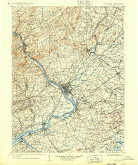
The Delaware River serves as a geographic anchor for this mid-1980s landscape, marking the state boundary between Pennsylvania and New Jersey. The capital city of Trenton sits at the heart of a dense transit corridor, where the Amtrak and Conrail rail lines intersect with the New Jersey Turnpike and Garden State Parkway. This survey reflects the suburban and industrial maturity of the region, from the scholarly grounds of Princeton University and Rutgers University to the massive military presence at the Fort Dix Military Reservation and Mcguire Air Force Base. Along the coast, the map captures the transition from the industrial shoreline of Raritan Bay to the iconic Jersey Shore communities of Asbury Park and Point Pleasant Beach. Several revolutionary sites are preserved as green space, including Princeton Battlefield State Park and Monmouth Battlefield State Park, while the Delaware & Raritan Canal State Park traces the path of historic commerce.
Find a feature on this map
105 named features on this map. Tap any name to fly to it.
Don’t see what you’re looking for? This feature index may not catch every label — zoom into the map to look around manually.
Map Details
Editions of this 1986 Trenton Map
This is the sole edition of this map. No revisions or reprints were ever made.