1947 Map of Trenton West
USGS Topo · Published 1947About this map
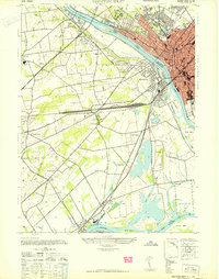
The Delaware River serves as the central artery between the urban density of Trenton and the developing townships of Bucks County in this mid-century survey. On the New Jersey side, the landscape is defined by civic institutions and leisure spaces, including the NJ State Hospital, the NJ State Home, and the Trenton Country Club. The historical weight of the region is anchored by the Wm Trent House 1719, standing near the industrial activity of the Pennsylvania Railroad and the Reading Company tracks.
Find a feature on this map
61 named features on this map. Tap any name to fly to it.
Don’t see what you’re looking for? This feature index may not catch every label — zoom into the map to look around manually.
Map Details
Editions of this 1947 Trenton West Map
This is the sole edition of this map. No revisions or reprints were ever made.
Other maps of this area

1888 · Bordentown
USGS Topo · 1:62,500

1888 · Princeton
USGS Topo · 1:62,500

1890 · Lambertville
USGS Topo · 1:62,500

1890 · Burlington
USGS Topo · 1:62,500

1891 · Lambertville
USGS Topo · 1:62,500

1893 · Bordentown
USGS Topo · 1:62,500

1893 · Burlington
USGS Topo · 1:62,500

1894 · Princeton
USGS Topo · 1:62,500

1894 · Lambertville
USGS Topo · 1:62,500

1904 · Burlington
USGS Topo · 1:62,500
Featured Places
- Hamilton Township, NJ
- Trenton, NJ
- Levittown, Bristol Township
- Middletown Township, PA
- Ewing Township, NJ