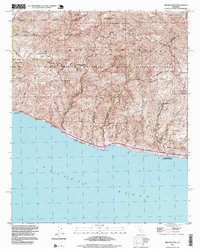
1994 Map of Triunfo Pass
USGS Topo · Published 1999About this map
The coastal mountains of Ventura and Los Angeles counties meet the Pacific Ocean in this mid-1990s survey. The landscape is defined by the sharp descent of the Santa Monica range toward the shoreline, where the Pacific Coast Highway skirts the bluff edges through Solromar and past Sequit Point. Inland, the terrain is dominated by steep drainage systems like Little Sycamore Canyon and Arroyo Sequit, which carve deep paths through the Santa Monica Mountains National Recreation Area.
Find a feature on this map
25 named features on this map. Tap any name to fly to it.
Don’t see what you’re looking for? This feature index may not catch every label — zoom into the map to look around manually.
Map Details
Editions of this 1994 Triunfo Pass Map
This is the sole edition of this map. No revisions or reprints were ever made.
Other maps of this area

1900 · Triunfo Pass
USGS Topo · 1:62,500

1903 · Camulos
USGS Topo · 1:125,000

1904 · Hueneme
USGS Topo · 1:62,500

1921 · Triunfo Pass
USGS Topo · 1:62,500

1929 · Dume Point
USGS Topo · 1:24,000

1932 · Dume Point
USGS Topo · 1:24,000

1932 · Russell Valley
USGS Topo · 1:24,000

1932 · Arroyo Sequit
USGS Topo · 1:24,000

1942 · Hueneme
USGS Topo · 1:62,500

1943 · Hueneme
USGS Topo · 1:62,500
Featured Places
- Malibu, CA
- South Beach, CA
- Unincorporated Santa Monica Mountains, CA
- Ventura County, CA
- Los Angeles County, CA