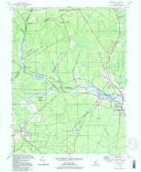
1994 Map of Tuckahoe
USGS Topo · Published 1998About this map
Tuckahoe and Woodbine anchor this landscape where the Tuckahoe River winds through the coastal plains of southern New Jersey. During the mid-1990s, the area remained defined by expansive conservation tracts, including the Peaslee State Wildlife Management Area and Belleplain State Forest. These protected lands preserve a traditional network of minor settlements and family-named landmarks like Steelmantown and Marshallville.
Find a feature on this map
68 named features on this map. Tap any name to fly to it.
Don’t see what you’re looking for? This feature index may not catch every label — zoom into the map to look around manually.
Map Details
Editions of this 1994 Tuckahoe Map
This is the sole edition of this map. No revisions or reprints were ever made.
Other maps of this area

1884 · Sea Isle
USGS Topo · 1:62,500

1888 · Dennisville
USGS Topo · 1:62,500

1888 · Sea Isle
USGS Topo · 1:62,500

1890 · Great Egg Harbor
USGS Topo · 1:62,500

1890 · Tuckahoe
USGS Topo · 1:62,500

1893 · Great Egg Harbor
USGS Topo · 1:62,500

1893 · Tuckahoe
USGS Topo · 1:62,500

1894 · Dennisville
USGS Topo · 1:62,500

1894 · Sea Isle
USGS Topo · 1:62,500

1918 · Great Egg Harbor
USGS Topo · 1:62,500