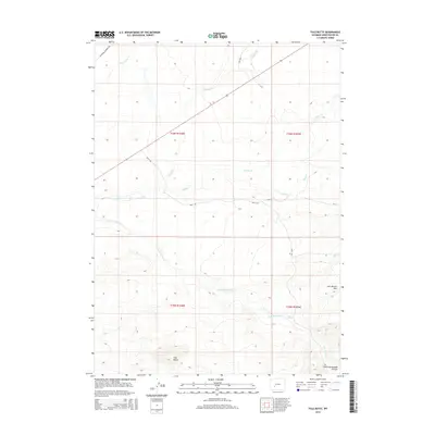
2015 Map of Tule Butte
USGS Topo · Published 2015About this map
California Mormon Rd cuts across this high desert landscape, tracing a historic passage through Sweetwater County. The terrain is defined by dramatic geological features such as the Tule Butte and the Jack Morrow Hills, which rise above a network of seasonal drainages including Jack Morrow Cr and N Pacific Cr. The mapping of local roads like Bar X Rd alongside ancient trails provides a clear view of how modern transportation corridors often follow the same paths used by early emigrants. In the southeast, the topography drops into South Packsaddle Canyon, while isolated water sources like Pete Spring highlight the critical role of hydrology in this arid region. This survey captures the intersection of historical transit routes and the physical geography of the Red Desert area.
Find a feature on this map
14 named features on this map. Tap any name to fly to it.
Don’t see what you’re looking for? This feature index may not catch every label — zoom into the map to look around manually.
Map Details
Editions of this 2015 Tule Butte Map
This is the sole edition of this map. No revisions or reprints were ever made.
Other maps of this area

1955 · Lander
USGS Topo · 1:250,000

1958 · Lander
USGS Topo · 1:250,000

1958 · Parting of the Ways
USGS Topo · 1:62,500

1958 · Essex Mountain
USGS Topo · 1:62,500

1958 · Hay Meadow Reservoir
USGS Topo · 1:24,000

1958 · Tule Butte
USGS Topo · 1:24,000

1958 · Parting of the Ways
USGS Topo · 1:24,000

1961 · Lander
USGS Topo · 1:250,000

1968 · Eden Reservoir East
USGS Topo · 1:24,000
1968 · Fifteenmile Spring
USGS Topo · 1:24,000