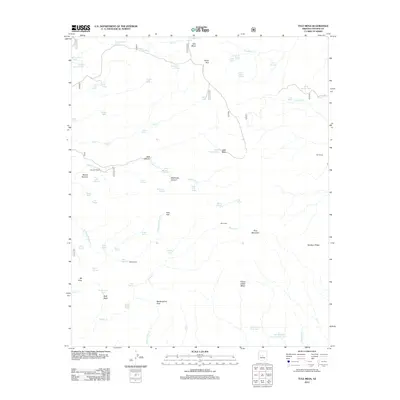
2012 Map of Tule Mesa
USGS Topo · Published 2012About this map
Pine Mountain and the high ridges of the Verde Rim define this area of Yavapai County as it was mapped in 2012. The landscape is marked by a complex network of canyons and mesas, including Tule Mesa, Yellow Jacket Mesa, and the prominent Skeleton Ridge. Water sources are critical features of this high-elevation terrain, evidenced by numerous tanks and springs like Nelson Place Spring, Tule Spring, and Black Alder Spring. Human presence is sparsely but clearly documented through established properties like the Double T Ranch and MT Ranch, alongside the isolated Mikes Cabin. These landmarks, connected by the winding Dougas Rd, illustrate the long-standing ranching and pastoral history of the region. The map also traces the various branches of Sycamore Cr and Bishop Cr, which carve through the land at Tank Canyon and Beehouse Canyon.
Find a feature on this map
72 named features on this map. Tap any name to fly to it.
Don’t see what you’re looking for? This feature index may not catch every label — zoom into the map to look around manually.
Map Details
Editions of this 2012 Tule Mesa Map
This is the sole edition of this map. No revisions or reprints were ever made.
Other maps of this area

1887 · Verde
USGS Topo · 1:250,000

1892 · Verde
USGS Topo · 1:250,000

1929 · Turret Peak
USGS Topo · 1:125,000

1933 · Turret Peak
USGS Topo · 1:125,000

1954 · Holbrook
USGS Topo · 1:250,000

1957 · Holbrook
USGS Topo · 1:250,000

1958 · Holbrook
USGS Topo · 1:250,000

1960 · Holbrook
USGS Topo · 1:250,000
1967 · Brooklyn Peak
USGS Topo · 1:24,000
1967 · Arnold Mesa
USGS Topo · 1:24,000