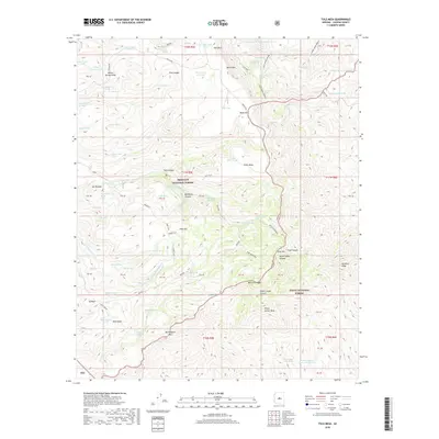
2018 Map of Tule Mesa
USGS Topo · Published 2018About this map
Pine Flat serves as a central reference point in this high-elevation landscape where the Prescott National Forest meets the Tonto National Forest. The dramatic topography is defined by the Verde Rim, a massive geological break that drops away into canyons like Beehouse Canyon and Yellow Jacket Canyon. This 2018 survey reveals a network of vital water sources necessary for cattle and wildlife in the arid climate, including family-named sites such as Nelson Place Spring and isolated basins like Buck Basin.
Find a feature on this map
89 named features on this map. Tap any name to fly to it.
Don’t see what you’re looking for? This feature index may not catch every label — zoom into the map to look around manually.
Map Details
Editions of this 2018 Tule Mesa Map
This is the sole edition of this map. No revisions or reprints were ever made.
Other maps of this area

1887 · Verde
USGS Topo · 1:250,000

1892 · Verde
USGS Topo · 1:250,000

1929 · Turret Peak
USGS Topo · 1:125,000

1933 · Turret Peak
USGS Topo · 1:125,000

1954 · Holbrook
USGS Topo · 1:250,000

1957 · Holbrook
USGS Topo · 1:250,000

1958 · Holbrook
USGS Topo · 1:250,000

1960 · Holbrook
USGS Topo · 1:250,000
1967 · Brooklyn Peak
USGS Topo · 1:24,000
1967 · Arnold Mesa
USGS Topo · 1:24,000