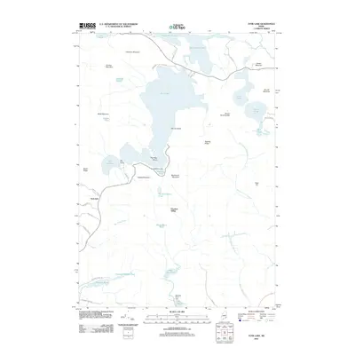
2011 Map of Tunk Lake
USGS Topo · Published 2011About this map
Tunk Lake dominates this inland Hancock County landscape, where the granite peaks of the Downeast region rise sharply above a dense network of glacial ponds and streams. In the early 21st century, this area maintains its character as a managed wilderness and recreational destination, evidenced by the Big Chief Camps and the intricate system of small water bodies like Little Tunk Pond and Wizard Pond. The topography is defined by significant elevations including Catherine Mountain, Black Mountain, and Blackwood Mountain, which frame the deep waters of the main lake. Evidence of local water management and perhaps former industrial use can be seen at Barbless Pond Dam and West Bay Pond Dam. Further south, the map identifies Goodwin Siding, a name often associated with the rail history of the region, situated near the headwaters of Chicken Mill Stream.
Find a feature on this map
52 named features on this map. Tap any name to fly to it.
Don’t see what you’re looking for? This feature index may not catch every label — zoom into the map to look around manually.
Map Details
Editions of this 2011 Tunk Lake Map
This is the sole edition of this map. No revisions or reprints were ever made.
Other maps of this area

1902 · Cherryfield
USGS Topo · 1:62,500

1904 · Cherryfield
USGS Topo · 1:62,500

1904 · Bar Harbor
USGS Topo · 1:62,500

1904 · Petit Manan
USGS Topo · 1:62,500

1930 · Tunk Lake
USGS Topo · 1:48,000

1932 · Tunk Lake
USGS Topo · 1:62,500

1942 · Bar Harbor
USGS Topo · 1:62,500

1942 · Cherryfield
USGS Topo · 1:62,500

1942 · Tunk Lake
USGS Topo · 1:62,500

1948 · Bangor
USGS Topo · 1:250,000