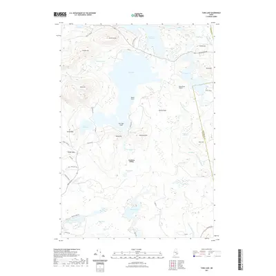
2021 Map of Tunk Lake
USGS Topo · Published 2021About this map
Catherine Mtn and Caribou Mtn anchor the northern highlands of this coastal Maine landscape, where the terrain is defined by a dense network of glacial ponds and granite peaks. The central feature, Tunk Lake, is surrounded by several smaller water bodies including Wizard Pond, Barbless Pond, and Big Muckleberry Pond. Near the center of the sheet, Goodwin Siding represents a point of historical human activity amidst the woods, while the eastern boundary follows the Washington Co and Hancock Co line through Deer Hill. Extensive wetlands such as Catskin Heath and Bogus Meadow fill the lowlands between ridges like Basking Ridge and Blackwood Mtn, illustrating the complex drainage patterns of Tunk Stream and Whitten Parritt Stream.
Find a feature on this map
65 named features on this map. Tap any name to fly to it.
Don’t see what you’re looking for? This feature index may not catch every label — zoom into the map to look around manually.
Map Details
Editions of this 2021 Tunk Lake Map
This is the sole edition of this map. No revisions or reprints were ever made.
Other maps of this area

1902 · Cherryfield
USGS Topo · 1:62,500

1904 · Cherryfield
USGS Topo · 1:62,500

1904 · Bar Harbor
USGS Topo · 1:62,500

1904 · Petit Manan
USGS Topo · 1:62,500

1930 · Tunk Lake
USGS Topo · 1:48,000

1932 · Tunk Lake
USGS Topo · 1:62,500

1942 · Bar Harbor
USGS Topo · 1:62,500

1942 · Cherryfield
USGS Topo · 1:62,500

1942 · Tunk Lake
USGS Topo · 1:62,500

1948 · Bangor
USGS Topo · 1:250,000