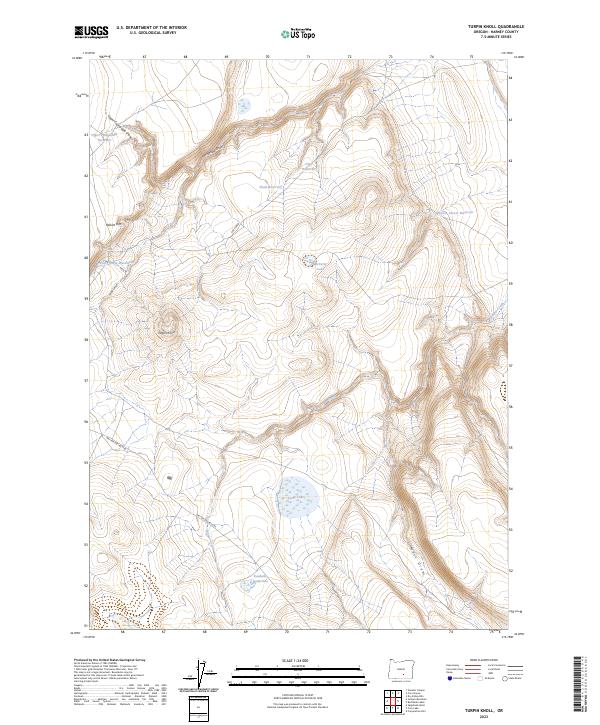
2023 Map of Turpin Knoll
USGS Topo · Published 2023About this map
Turpin Knoll serves as the central landmark in this high-desert landscape of southeastern Oregon, where a sophisticated network of water management features tells the story of ranching and resource conservation. The map details an extensive system of catchments including Upper Packsaddle Reservoir, Shale Reservoir, and Clay Reservoir, alongside named points like the McCarty Cabin Waterhole. These features, integrated with the natural drainage of Packsaddle Draw and Cox Canyon, reflect the vital importance of water security in Harney County's arid terrain. The presence of Large Lake and the Roadside Waterhole along the Nat For Dev Rd 6185 illustrates the intersection of natural hydrology and human infrastructure in this remote part of the state.
Find a feature on this map
21 named features on this map. Tap any name to fly to it.
Don’t see what you’re looking for? This feature index may not catch every label — zoom into the map to look around manually.
Map Details
Editions of this 2023 Turpin Knoll Map
This is the sole edition of this map. No revisions or reprints were ever made.
Other maps of this area

1955 · Burns
USGS Topo · 1:250,000

1955 · Adel
USGS Topo · 1:250,000

1957 · Adel
USGS Topo · 1:250,000

1958 · Burns
USGS Topo · 1:250,000

1958 · Adel
USGS Topo · 1:250,000

1959 · Burns
USGS Topo · 1:250,000

1962 · Adel
USGS Topo · 1:250,000
1971 · Corporation Rim
USGS Topo · 1:24,000
1971 · Red Bank Lakes
USGS Topo · 1:24,000
1984 · Turpin Knoll
USGS Topo · 1:24,000