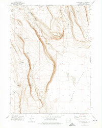
1971 Map of Corporation Rim
USGS Topo · Published 1974About this map
Warner Valley dominates the eastern expanse of this high-desert landscape, bordered by the dramatic elevation changes of Corporation Rim. This 1971 survey captures the remote cattle-country infrastructure of Harney County, characterized by a network of seasonal water sources like North Desert Waterhole, Barney Waterhole, and Knob Reservoir. These scattered features were essential for supporting livestock in an arid environment where natural springs are rare.
Find a feature on this map
20 named features on this map. Tap any name to fly to it.
Don’t see what you’re looking for? This feature index may not catch every label — zoom into the map to look around manually.
Map Details
Editions of this 1971 Corporation Rim Map
2 editions found
Other maps of this area

1955 · Adel
USGS Topo · 1:250,000

1957 · Adel
USGS Topo · 1:250,000

1958 · Adel
USGS Topo · 1:250,000

1962 · Adel
USGS Topo · 1:250,000

1966 · Bluejoint Lake East
USGS Topo · 1:24,000

1966 · Rabbit Hills NE
USGS Topo · 1:24,000

1967 · Bluejoint Lake West
USGS Topo · 1:24,000

1971 · Steamboat Point
USGS Topo · 1:24,000

1971 · Rock Camp Draw
USGS Topo · 1:24,000
1971 · Red Bank Lakes
USGS Topo · 1:24,000