
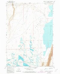
1967 Map of Bluejoint Lake West
USGS Topo · Published 1969About this map
Warner Valley's high desert floor is meticulously detailed in this late-1960s survey, illustrating a landscape defined by seasonal water and alkaline basins. The ephemeral nature of the Warner Lakes system is evident through the sprawling Alkali Flats and the distinct outlines of Turpin Lake and Stone Corral Lake. To the east, the steep escarpment of Poker Jim Ridge rises sharply, marking the western boundary of the Hart Mtn National Antelope Refuge.
Find a feature on this map
15 named features on this map. Tap any name to fly to it.
Don’t see what you’re looking for? This feature index may not catch every label — zoom into the map to look around manually.
Map Details
Editions of this 1967 Bluejoint Lake West Map
2 editions found
Other maps of this area

1955 · Adel
USGS Topo · 1:250,000

1957 · Adel
USGS Topo · 1:250,000

1958 · Adel
USGS Topo · 1:250,000

1962 · Adel
USGS Topo · 1:250,000

1966 · Bluejoint Lake East
USGS Topo · 1:24,000

1966 · Rabbit Hills NE
USGS Topo · 1:24,000

1967 · Flagstaff Lake
USGS Topo · 1:24,000

1967 · Campbell Lake
USGS Topo · 1:24,000

1967 · Flook Lake
USGS Topo · 1:24,000

1971 · Steamboat Point
USGS Topo · 1:24,000