
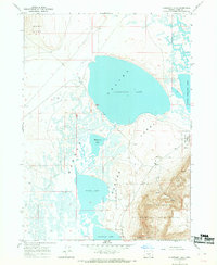
1967 Map of Flagstaff Lake
USGS Topo · Published 1969About this map
Flagstaff Lake dominates this high-desert basin in Lake County, Oregon, revealing a complex hydrological system of intermittent water bodies known collectively as the Warner Lakes. This 1967 field-checked survey illustrates the transition from the arid Alkali Flats to the significant depths of Mugwump Lake, Swamp Lake, and Anderson Lake. To the east, the dramatic elevation of Hart Mountain rises sharply from the basin floor, serving as a backdrop for the Hart Mountain National Antelope Refuge. The landscape is defined by its geological extremes, from the rugged Mulkey Canyon and the Rabbit Hills to the seasonal pools and springs that sustain the local wildlife. A solitary Jeep Trail and a few unimproved roads provide the only access through this sensitive ecosystem, while a Gravel Pit indicates localized resource extraction near the refuge boundary.
Find a feature on this map
16 named features on this map. Tap any name to fly to it.
Don’t see what you’re looking for? This feature index may not catch every label — zoom into the map to look around manually.
Map Details
Editions of this 1967 Flagstaff Lake Map
2 editions found
Other maps of this area

1955 · Adel
USGS Topo · 1:250,000

1957 · Adel
USGS Topo · 1:250,000

1958 · Adel
USGS Topo · 1:250,000

1962 · Adel
USGS Topo · 1:250,000

1966 · Rabbit Hills NE
USGS Topo · 1:24,000

1966 · Rabbit Hills NW
USGS Topo · 1:24,000

1967 · Plush
USGS Topo · 1:24,000

1967 · Rabbit Hills SW
USGS Topo · 1:24,000

1967 · Campbell Lake
USGS Topo · 1:24,000

1967 · Bluejoint Lake West
USGS Topo · 1:24,000