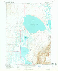
1967 Map of Flagstaff Lake
USGS Topo · Published 1969About this map
Flagstaff Lake and the interconnected waters of the Warner Valley Lakes dominate this high-desert basin in southeastern Oregon. Surveyed in the mid-1960s, the map reveals a landscape defined by dramatic elevation shifts, where the massive fault block of Hart Mountain rises sharply from the valley floor. This eastern portion of the quadrangle is largely contained within the Hart Mountain National Antelope Refuge, protecting the habitat of indigenous wildlife across terrain marked by steep escarpments and seasonal drainages like Mulkey Creek. The valley itself is a complex of shallow basins including Mugwump Lake, Swamp Lake, and Upper Campbell Lake, often bordered by extensive Alkali Flats. To the northwest, the Rabbit Hills provide a northern boundary to the flats, while a network of primitive transportation is represented by a Jeep Trail winding through the refuge and occasional sites such as a Gravel Pit.
Find a feature on this map
19 named features on this map. Tap any name to fly to it.
Don’t see what you’re looking for? This feature index may not catch every label — zoom into the map to look around manually.
Map Details
Editions of this 1967 Flagstaff Lake Map
2 editions found
Other maps of this area

1955 · Adel
USGS Topo · 1:250,000

1957 · Adel
USGS Topo · 1:250,000

1958 · Adel
USGS Topo · 1:250,000

1962 · Adel
USGS Topo · 1:250,000

1966 · Rabbit Hills NE
USGS Topo · 1:24,000

1966 · Rabbit Hills NW
USGS Topo · 1:24,000

1967 · Flagstaff Lake
USGS Topo · 1:24,000

1967 · Plush
USGS Topo · 1:24,000

1967 · Rabbit Hills SW
USGS Topo · 1:24,000

1967 · Campbell Lake
USGS Topo · 1:24,000