
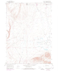
1966 Map of Rabbit Hills NW
USGS Topo · Published 1969About this map
Flint Hills and Flint Ridge dominate the northwestern portion of this 1960s survey, marking a rugged high-desert landscape on the border of Harney and Lake counties. The topography is defined by significant elevation changes, dropping into the expansive Rabbit Basin where Rabbit Creek winds through the flats. This era shows a transition between traditional range land and early modern recreational or survey access, indicated by the network of tracks such as Hogback Road and various Jeep Trails that crisscross the sagebrush and volcanic terrain.
Find a feature on this map
12 named features on this map. Tap any name to fly to it.
Don’t see what you’re looking for? This feature index may not catch every label — zoom into the map to look around manually.
Map Details
Editions of this 1966 Rabbit Hills NW Map
2 editions found
Other maps of this area

1955 · Klamath Falls
USGS Topo · 1:250,000

1955 · Adel
USGS Topo · 1:250,000

1957 · Adel
USGS Topo · 1:250,000

1958 · Klamath Falls
USGS Topo · 1:250,000

1958 · Adel
USGS Topo · 1:250,000

1962 · Adel
USGS Topo · 1:250,000

1966 · Rabbit Hills NE
USGS Topo · 1:24,000

1967 · Flagstaff Lake
USGS Topo · 1:24,000

1967 · Rabbit Hills SW
USGS Topo · 1:24,000
1968 · Cooper Draw
USGS Topo · 1:24,000