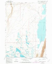
1967 Map of Bluejoint Lake West
USGS Topo · Published 1980About this map
Warner Valley defines the topography of this high desert landscape, where the interconnected waters of the Warner Lakes system dominate the floor. The eastern edge is sharply bounded by the dramatic rise of Poker Jim Ridge, which falls within the protective boundary of the Hart Mtn National Antelope Refuge. This 1967 survey, updated with 1979 photorevisions, captures a complex hydrology of ephemeral and permanent water bodies, including Bluejoint Lake, Turpin Lake, and Stone Corral Lake.
Find a feature on this map
16 named features on this map. Tap any name to fly to it.
Don’t see what you’re looking for? This feature index may not catch every label — zoom into the map to look around manually.
Map Details
Editions of this 1967 Bluejoint Lake West Map
2 editions found
Other maps of this area

1955 · Adel
USGS Topo · 1:250,000

1957 · Adel
USGS Topo · 1:250,000

1958 · Adel
USGS Topo · 1:250,000

1962 · Adel
USGS Topo · 1:250,000

1966 · Bluejoint Lake East
USGS Topo · 1:24,000

1966 · Rabbit Hills NE
USGS Topo · 1:24,000

1967 · Flagstaff Lake
USGS Topo · 1:24,000

1967 · Campbell Lake
USGS Topo · 1:24,000

1967 · Flook Lake
USGS Topo · 1:24,000

1967 · Bluejoint Lake West
USGS Topo · 1:24,000