1883 Map of Tusayan
USGS Topo · Published 1896About this map
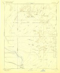
The Province of Tusayan is mapped here during the early 1880s, revealing a landscape defined by the ancient mesas and the emerging influence of the railroad. This reconnaissance work, overseen by J.W. Powell, documents the complex of Hopi villages including Oraibi, Walpi, Hano, and Si-chom-i-vi clustered in the northern portion of the sheet. These traditional settlements stand in sharp contrast to the new towns forming along the southern corridor, where the Atlantic and Pacific Rail Road tracks parallel the Little Colorado River.
Find a feature on this map
32 named features on this map. Tap any name to fly to it.
Don’t see what you’re looking for? This feature index may not catch every label — zoom into the map to look around manually.
Map Details
Editions of this 1883 Tusayan Map
This is the sole edition of this map. No revisions or reprints were ever made.