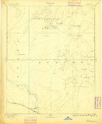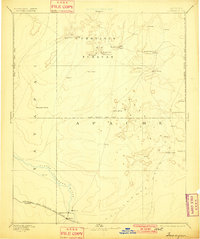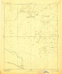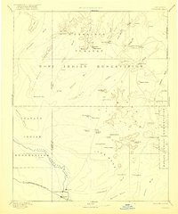
1886 Map of Tusayan
USGS Topo · Published 1921About this map
Province Tusayan dominates this 1880s reconnaissance, centered on the ancient mesa-top villages of the Hopi Indian Reservation. The map captures a significant ethnographic landscape, detailing the clustered settlements of Oraibi, Shongopovi, and Walpi situated atop Third Mesa, Second Mesa, and First Mesa. To the south, the expansion of the American West is evident along the Little Colorado River, where the Atchison Topeka and Santa Fe railroad corridor brings new infrastructure through Winslow and the early settlements of Sunset and Brigham City. The vast territory is defined by seasonal washes like Polacca Wash and Dinnebito Wash that cut through prominent landforms such as Tovar Mesa and Ives Mesa. This survey provides a rare look at the distribution of Hopi pueblos and Navajo territory before the heavy influence of modern development, recording numerous springs and landmarks like Montezumas Chair and Keams Cañon.
Find a feature on this map
67 named features on this map. Tap any name to fly to it.
Don’t see what you’re looking for? This feature index may not catch every label — zoom into the map to look around manually.
Map Details
Editions of this 1886 Tusayan Map
5 editions found