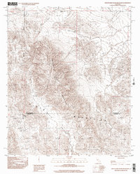
1997 Map of Twentynine Palms Mountain
USGS Topo · Published 2002About this map
The San Bernardino and Riverside County line divides this high-desert landscape, where the Twentynine Palms Mountain and Pinto Mountain ranges meet. This 1997 provisional survey documents an area heavily influenced by mineral extraction and specialized land use, centered around the settlement of Gold Park. The terrain is characterized by steep, dramatic elevation changes, with Music Valley and Malapai Wash cutting through the arid landscape.
Find a feature on this map
14 named features on this map. Tap any name to fly to it.
Don’t see what you’re looking for? This feature index may not catch every label — zoom into the map to look around manually.
Map Details
Editions of this 1997 Twentynine Palms Mountain Map
This is the sole edition of this map. No revisions or reprints were ever made.
Other maps of this area

1942 · Amboy
USGS Topo · 1:250,000

1943 · Amboy
USGS Topo · 1:250,000

1943 · Pinkham Well
USGS Topo · 1:62,500

1944 · Pinkham Well
USGS Topo · 1:62,500

1944 · Pinyon Well
USGS Topo · 1:62,500

1947 · Santa Ana
USGS Topo · 1:250,000

1949 · Santa Ana
USGS Topo · 1:250,000

1953 · San Bernardino
USGS Topo · 1:250,000

1954 · Salton Sea
USGS Topo · 1:250,000

1954 · Needles
USGS Topo · 1:250,000