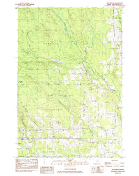
1984 Map of Twin Brook
USGS Topo · Published 1984About this map
Ludlow and Hammond townships in southern Aroostook County are defined by a network of drainage systems feeding into the Webster Brook and Moose Brook basins. The landscape reflects the rural character of northern Maine in the early 1980s, where small-scale extraction is evidenced by Gravel Pits near the New Limerick border. This area serves as a transition between the more developed corridors of Houlton and the marshy, low-lying environments of Cameron Bog and Bradbury Lake to the west.
Find a feature on this map
22 named features on this map. Tap any name to fly to it.
Don’t see what you’re looking for? This feature index may not catch every label — zoom into the map to look around manually.
Map Details
Editions of this 1984 Twin Brook Map
This is the sole edition of this map. No revisions or reprints were ever made.
Other maps of this area

1934 · Bridgewater
USGS Topo · 1:48,000

1935 · Howe Brook
USGS Topo · 1:48,000

1937 · Smyrna Mills
USGS Topo · 1:62,500

1938 · Bridgewater
USGS Topo · 1:62,500

1938 · Houlton
USGS Topo · 1:62,500

1939 · Howe Brook
USGS Topo · 1:62,500

1951 · Houlton
USGS Topo · 1:62,500

1951 · Bridgewater
USGS Topo · 1:62,500

1953 · Bridgewater
USGS Topo · 1:50,000

1954 · Howe Brook
USGS Topo · 1:62,500